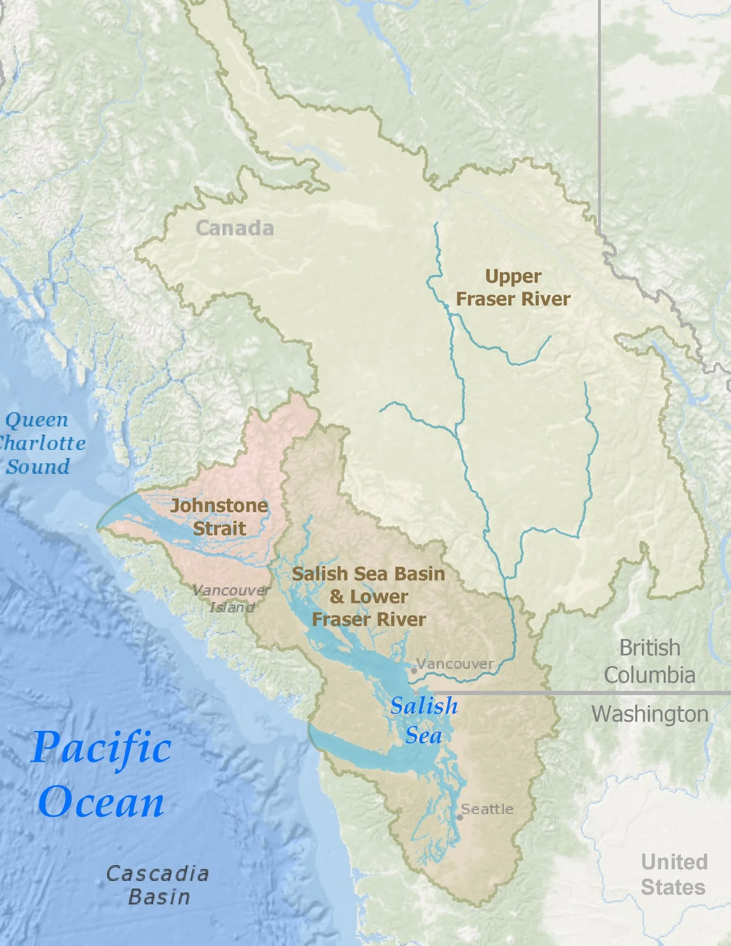
The Salish Sea & Surrounding Basin
In the fall of 2009 and winter of 2010 the Washington State Board on Geographic Names, the Province of British Columbia Geographic Names Office, the U.S. Board on Geographic Names and the Geographical Names Board of Canada each approved the name ‘Salish Sea‘ as an official designation for the inland marine waters of Washington and British Columbia.
The SALISH SEA (Mer des Salish) extends from the north end of the Strait of Georgia and Desolation Sound to the south end of the Puget Sound and west to the mouth of the Strait of Juan de Fuca, including the inland marine waters of southern British Columbia, Canada and northern Washington, USA. These separately named bodies of water form a single estuarine ecosystem. ‘The Salish Sea’ as a name for these waters has been embraced by citizens on both sides of the border for years including the Coast Salish Gathering (the alliance of Coast Salish Tribal and First Nations leaders).
The Salish Sea is connected to the Pacific Ocean primarily via the Strait of Juan de Fuca (with relatively slight tidal influence from the north around Vancouver Island and through Johnstone Strait) and is largely contained by Vancouver Island and the Olympic Peninsula. In addition to the Gulf and San Juan Islands the watershed contains the lower Fraser River Delta and the Puget Lowlands as well as the Hood Canal, the Tacoma Narrows and Deception Pass.
Over 9 million people live within the drainage basin of the Salish Sea [1] (sometimes referred to as the “Georgia Basin – Puget Sound” watershed), including the cities of Vancouver, Seattle, Victoria, Olympia, Nanaimo, Bellingham, Everett, Port Angeles, Port Townsend and Tacoma.
The Salish Sea and Surrounding Basin, Stefan Freelan, 2023
-
The surface area of the Salish Sea (saltwater) is approximately 18,000 sq. km. (or about 7,000 sq. miles). [4] Within the Salish Sea there are hundreds of islands (or even thousands, depending upon one’s definition of an ‘island’ (see discussion on island counting, below). The deepest point of the Salish Sea is 660 m., in Jervis Inlet. The highest point of the surrounding basin in Mt. Rainier (4,392 m.).
Strait of Georgia (including the N. Gulf Islands):
Maximum depth: 410 m.
Surface Area: 6,400 sq. km.
% of Salish Sea: 36 %Strait of Juan de Fuca:
Maximum depth: 250 m.
Surface Area: 4,400 sq. km.
% of Salish Sea: 24 %Desolation Sound:
Maximum Depth: 600 m.
Surface Area: 1,100 sq. km.
% of Salish Sea: 6 %Puget Sound:
Maximum Depth: 280 m.
Surface Area: 2,500 sq. km.
% of Salish Sea: 14 %Other BC (including Discovery Passage, Jervis Inlet, Howe Sound, S. Gulf Islands):
Maximim Depth: 660 m.
Surface Area: 2,000 sq. km.
% of Salish Sea: 11 %Other WA (including Haro Strait, Rosario Strait, San Juan Islands, Bellingham Bay, Padilla Bay):
Maximum Depth: 300 m.
Surface Area: 1,600 sq. km.
% of Salish Sea: 9 %- - - - - - - - - - - - - - - - - - - - -
British Columbia, Canada:
Maximum Depth: 660 m.
Surface Area: 10,800 sq. km.
% of Salish Sea: 60%Washington, USA:
Maximum Depth: 300 m.
Surface Area: 7,200 sq. km.
% of Salish Sea: 40%- - - - - - - - - - - - - - - - - - - - -
Combined Salish Sea:
Maximum Depth: 660 m. (2,165 ft.)
Surface Area: 18,000 sq. km. (~7,000 sq. mi.) -
Cartographer: Stefan Freelan, (About) 2023 (original map created in 2009)
Software: ESRI’s ArcGIS Pro 3.x
Elevation Data: USGS, Living Atlas, SRTM (CGIAR-CSI) [2]
Bathymetry Data: NOAA
Additional Data: BC Freshwater Atlas, NSICS GLIMS, Wa. DOE, ESRI
The map of Salish Sea and Surrounding Basin was produced using a Geographic Information System (GIS) and publicly available spatial datasets for elevation, bathymetry and hydrology.
Variations of color on the map are based on elevation, not landcover (a process known as hypsometric shading). Colors were chosen to mimic the ‘feel’ of the Pacific coast landscape (lighter greens for the lowlands, white for the mountain peaks). In addition, a ‘hillshade’ effect has been created casting a virtual ‘shadow’ across the landscape to better depict the topography as if one is seeing a 3-dimensional shaded relief model. Similar color gradations are applied to the bathymetric data, again with a shadow effect applied as a ‘floorshade’ (i.e. a ‘hill’-shade for the ocean floor).
The Salish Sea basin boundary was derived from the elevation data following the peaks and ridges surrounding the Salish Sea. Areas outside the basin have been shaded with a semi-transparent overlay to highlight the geographic area draining directly into the Salish Sea. Note that the entire upper Fraser River watershed is technically a part of the Salish Sea drainage area. For this map, however, the Salish Sea basin has been defined as just that area draining directly into the ocean, including only the lower Fraser River watershed. See Basin Boundary Notes (below) for a larger discussion on the use of the term ‘basin’ and the choice to exclude the watershed of the upper Fraser River. See the Combined Watersheds Draining into the Salish Sea for a map of the full Salish Sea drainage area.
Note that some definitions of the Salish Sea exclude Bute Inlet at the northern boundary (north of Desolation Sound).
It is unusual for a map of this type to not include the cities, roads and borders that have been created by humans. Instead, this map focuses on the Salish Sea and its surrounding basin, defined not by political jurisdictions but by the geography of the water and land itself. As such, the text labels on the main map are likewise used only for the natural features defining and surrounding the Salish Sea.
-
Why Doesn’t the Map Include the Upper Fraser River Watershed?
The map of the Salish Sea and Surrounding Basin depicts a ‘basin boundary’ surrounding the Salish Sea that excludes the entire upper section of the Fraser River (for comparison, see a map of all of the Combined Watersheds Draining to the Salish Sea).
As the intent of the map is to highlight the Salish Sea, excluding the upper Fraser River allows that to be the primary focus. Moreover, the basin boundary (excluding the upper Fraser River) captures the area of land that is most associated with, most influenced by, and which has the most influence upon, the marine ecosystem of the Salish Sea.
Why use 'Basin Boundary' Instead of 'Watershed'?
With the exception of the upper Fraser River (and the mouth of the Strait of Juan de Fuca and Johnstone Strait) the Basin Boundary shown on the map is the same as the watershed boundary for the Salish Sea (i.e., the combined watersheds of the rivers draining directly into the Salish Sea). However, given the exclusion of the upper Fraser the term 'watershed' is not appropriate.
The term 'basin' is similar to the term 'watershed. Indeed, 'catchment basin' can be used interchangeably with the term watershed. More generally, a basin is defined as a low area surrounded by higher land or a bowl-shaped depression in the land or sea. In addition, basin can also be used to describe a 'cultural basin', a 'service area basin' or a 'weather basin'... Thus the term basin is somewhat less narrowly defined, and thus more appropriate for this map (both geographically and culturally).
Other terms that were considered were 'bowl' and 'viewshed' - both of which convey some of the sense of the basin boundary being the extent of the area within sight of the Salish Sea (or the top of the rim of the surrounding bowl). But the term viewshed has a specific meaning that does not apply, given the undulating terrain, and 'bowl' is hardly a common geographical term.
The bottom line is that while the boundary on the map is almost a watershed delineation, the term is not appropriate given the exclusion of the upper Fraser River. Instead, the term 'basin boundary', being more vague, was used, appreciating the fact that it sounds a lot like a watershed but also could be applied as a ‘cultural basin’ etc. Admittedly, most people probably confuse ‘basin’ with the terms watershed or hydrological catchment, and that association is somewhat appropriate, since most of the basin boundary is the watershed boundary.
In short, the goal was to be as descriptive as possible without being scientifically incorrect.
Note that some definitions of the Salish Sea exclude Bute Inlet at the northern boundary (north of Desolation Sound).
-
One would think that two of the most basic questions about the Salish Sea (or any body of water) would be: How Many Islands Are There? and What is the Length of the Shoreline? Interestingly, there is no single, correct answer to either of these questions.
The number of islands depends entirely upon how one defines an island: is a 1 acre rock an island? How about a 20 sq. m. rock? Do we measure those rocks/islands at high tide or low tide? And is the average high tide, or a high high tide? Does it need to have a name to be considered an island? Does it need to be inhabited?… It goes on and on, and (oddly) there does not seem to be any consensus or standard, either from geographers or government officials, as to what constitutes an island. Lacking such a definition, getting an accurate count is impossible. Somewhat related to the idea of defining an ‘island’ is the quality of our maps / data: assuming we had a working definition, do we determine what qualifies as an island via air photos, existing GIS data sets or field surveys? (Oh, and did I mention that sea level, and thus potentially island existence, can change?)
Measuring shoreline length is even worse. Indeed, it turns out that it’s impossible to accurately measure the length of a shoreline. Beyond the quality of the data one is using, it also depends upon the length of the measuring device/unit that is used to do the measuring. And the shorter the unit of measurement, the greater the measured length of shoreline is. This is known as the “Coastline Paradox” and the fractal mathematicians have lots to say on the subject (concluding that the length of any shoreline, if measured with a small enough measuring device, is infinite). This challenge isn’t unique to the Salish Sea, of course. Estimates for the length of the USA shoreline vary from 12,383 miles (Congressional Research Institute) to 18,924 miles (CIA) to 95,471 miles (NOAA)… that’s a pretty big range, all from the same federal government, for something as basic as ‘how long is our coast’…
-
Public use and reproduction for non-commercial purposes is permitted (see Printing).
Reproduction of this map for other websites or publications is permitted with the following conditions:
– Please include a map citation:
“Map of the Salish Sea & Surrounding Basin, Stefan Freelan, 2023”
– Please let me know how and where you are using it
– Sale of this map is prohibited without explicit permission from the cartographer
- - - - - - - - - - - - - - - - - - - - -
The original purpose of the Salish Sea Map was as an educational effort of the name (and concept) of the “Salish Sea” as part of generating greater awareness and protection of the marine waters and surrounding lands that makeup the Salish Sea ecosystem.
Over the years I’ve given hundreds of people and projects permission to use the map (for non-commercial purposes). Below is a very incomplete list of some of the places that have used it. I am honored that my map has connected with so many people doing such good work.
In no particular order… a small sampling of places the map of the Salish Sea has been seen…
The Salish Sea – A Single Body of Life (video)
The Salish Sea Institute (WWU)
Health of the Salish Sea Report – US EPA
The Great Salish Sea – Dany Lyons (CD – album cover adapted)
Hiking Naked, by Iris Graville (book)
Padilla Bay National Estuarine Research Reserve (gift store)
-
The name “Salish Sea” is not a historical term for the inland waters of British Columbia and Washington State. It was proposed by marine biologist Bert Webber in 1988. Dr. Webber recognized the need for a single geographic term that encompassed the entire ecosystem, spanning across the international border. Having a name to identify the entire area calls attention to the trans-border commonality of water, air, wildlife and history. Rather than being a replacement for any of the existing names, the designation Salish Sea is an overlay term which includes and unites the established and familiar names of the various water and land bodies (the Strait of Georgia, Strait of Juan de Fuca, Puget Sound, Gulf Islands, San Juan Islands, etc.). The name also pays tribute to the Coast Salish peoples who have inhabited the area since long before Euro-American explorers first arrived.
Over the next two decades the name Salish Sea gradually came to have wide-spread adoption, notably by local scientists and natural resource managers, including many of the indigenous tribes and organizations.
In 2009 the governments of both British Columbia and Washington officially adopted the name Salish Sea. [3]
Below are some links related to Bert Webber and the naming process.
VIDEO
Official Naming of the Salish Sea (Coast Salish Gathering, 2010)
The Salish Sea: What’s in a Name (Bert Webber, Speaking of Maps, 2016)
The Salish Sea, with Bert Webber (Whatcom Historical Society, 2018)
AUDIO
Return To The Salish Sea: Visionary Bert Webber (KNKX, 2017)
Visionary Bert Webber: “Good Science Is Stewardship” (KNKX, 2017)
ARTICLES
Meet the Man Behind the Salish Sea (The Globe and Mail, Sid Tafler, 2008)
“Salish Sea”: WA Inland Waters Name now Official (Investigate West, 2009)
Setting Sail for the Salish Sea (Crosscut, Knute Berger, 2009)
The ‘Discovery’ of the Salish Sea (Crosscut, Bert Webber, 2011)
How the Salish Sea got it’s Name (SeaDoc Society, Bert Webber, 2011)
Naming the Salish Sea: How and Why it Happened (Bert Webber, 2011)
-
A handful of links related to the Salish Sea…
Web map of the Salish Sea and Surrounding Basin
WWU’s Salish Sea Institute
Salish Sea Ecosystem Conference
-
1. GIS calculations derived from US Census Bureau data and Canadian Census statistics.
2. 2008, Hole-filled SRTM for the globe Version 4, Jarvis, A., H.I. Reuter, A. Nelson, E. Guevara, (CGIAR-CSI SRTM 90m Database).
3. The Washington State Board on Geographic Names (see naming guidelines); The Province of British Columbia Geographic Names Office; The U.S. Board on Geographic Names; The Geographic Names Board of Canada; The ‘Discovery of the Salish Sea’
4. GIS calculations derived from SRTM elevation data.
5. Water Properties in the Straits of Georgia and Juan de Fuca, Emilie Davenne and Diane Masson, Institute of Ocean Sciences, Sidney, BC, Canada, 2001.
6. Puget Sound Model Summary, John H. Lincoln, University of Washington, Department of Oceanography, Seattle, Wa.
7. Species of Concern within the Georgia Basin Puget Sound Marine Ecosystem: Changes from 2002 to 2006, Nicholas A. Brown and Joseph K. Gaydos, The SeaDoc Society, 2007.
8. Puget Sound Georgia Basin Ecosystem, US EPA website, 2009.
.
See also Talks and Interviews I've given on the process of creating the Salish Sea map